The rapid spread of wheel cactus across regional Victoria is challenging farmers in the area, with both public and private landholders joining forces to try and curb the outbreak.
Noxious weed spreads rapidly in Northern Victoria
Wheel cactus (Opuntia robusta) is a noxious and extremely invasive weed, smothering the local environment and invading farm properties in rural Victoria (Hynninen, 2021).
Eradication of wheel cactus is labour intensive. It is an extremely stubborn weed that can reproduce from both seed and vegetative fragments (Tarrangower Cactus Control Group, n.d.). It is also drought resistant, making it extremely comfortable in the Australian landscape. Wheel cactus is now classified as a “weed of national significance”.
The difficulty this weed presents for farmers and the speed at which it is spreading highlights not only the importance of pest monitoring and control, but the need for nationally representative research to monitor pest outbreaks and farmer pain points associated with them.
Mapping the spread of weeds such as wheel cactus
Mapping the spread of weed proliferation over time can be extremely useful for tracking outbreaks and managing eradication efforts.
There are some limitations, barriers, and difficulties when it comes to the specifics of data collection and mapping accuracy, especially when relying on accounts and observations from those not well trained in plant or weed identification.
Mapping specifically for wheel cactus in 2017
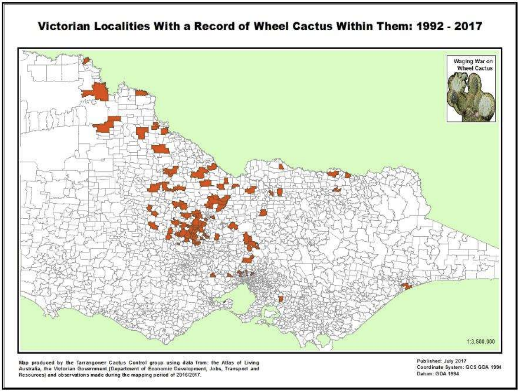
The “cactus warriors” from the Tarrangower Cactus Control Group (TCCG) have been battling the spread of wheel cactus around central Victorian districts for over 10 years and completed a project to map wheel cactus sites across the state in 2017 (Landcare Victoria, 2018). New observations and historical records were used to map the cactus at ‘locality scale” (figure 1).
Figure 1: Simplified map from 2017 TCCG wheel cactus mapping project. The map displays localities in Victoria that contain a record of Wheel Cactus in the last 25 years (Schlachter, 2017).
Unrecorded wheel cactus plant locations were obtained by sending out requests for information to the following sources (Schlachter, 2017):
- Regional Landcare Facilitators and Coordinators
- Local Landcare Facilitators
- Landcare Networks
- Local government staff
- Landcare magazines
- Facebook post
The study did indicate that there was difficulty in “positive identification” of wheel cactus plants as not all observers are well educated in cacta plant identification. Thus, new records with doubt surrounding species identification were not included.
ABARES Pest animals and weed management survey
ABARES conducted the national “pest animals and weed management” survey with agricultural land managers in 2016 and 2019, producing a “pest and weed survey” dashboard to accompany the report, which maps pest and animal weed impacts (Stenekes & Kancans, 2021).
Agricultural land managers were asked about the degree of the problem that Weeds of National Significance (WoNS) presented on their property in the last 12 months, with the survey covering 32 WoNs, including Opuntioide cacti species.
The dashboard maps “Land managers problem with weeds on property” for each 32 WoNs, but not particular sub species such as “wheel cactus” or “Opuntia robusta “on its own within the general species.
Tracking weed outbreaks across Australian farms
Tracking of weed prevalence and farmer management practices over time holds significance for Australia’s’ biosecurity.
Identification of pest outbreaks and farmer pain points associated with pest management practices are examples of key insights that such research can bring to light for resolution.
The ABARES 2019-16 pest animal and weed management survey is extremely valuable, but lack of survey repetition between 2016 and 2019 contributes to reduced uncertainty regarding changes in results over the period.
Differences in the level of agricultural activity between 2016 and 2019 and drought likely influenced the abundance and distribution of pests for example, which would then effect the differences in survey results (Stenekes & Kancans, 2021).
Furthermore, the study didn’t break down result for weeds into specific subspecies such as wheel cactus, which makes tracking of specific pest outbreaks from the survey alone not straight forward.
Surveying, mapping and tracking weeds prevalence with KG2
KG2 has deep experience surveying farmers and agribusiness about weeds, animal pests, and agricultural management practices, including the use of crop protection products such as herbicide insecticides and fungicides.
For example, in 2016, KG2 conducted a study on behalf of the Grains Research and Development Corporation (GRDC) about the “Impact of Weeds on Australian Grain Production”.
KG2 surveyed 600 Australian growers across 13 major agroecological Zones in Western, Southern and Northern growing regions about the economic pain points and management practices associated with weeds on agricultural land, alongside the prevalence of different weed species.
KG2 has also conducted tracking studies about Australian farmers’ use of crop protection products. This is part of Agscan, a portfolio of longitudinal tracking studies that KG2 conducts for a range of agricultural issues and industries.
Need to survey Australian farmers?
For more information on surveying farmers and large-scale tracking studies in the Australian agricultural industry, get in touch today.
SOURCES:
Hynninen, E. (2021, May 25). Noxious weed, wheel cactus, spreads in the millions across northern Victoria. ABC News. https://www.abc.net.au/news/rural/2021-05-25/wheel-cactus-spreads-across-northern-victoria/100160192
Tarrangower Cactus Control Group. (n.d.) What is Wheel Cactus? Retrieved 17 June, 2021 https://cactuswarriors.org/wheel-cactus/
Landcare Victoria. (2018). New wheel cactus map for Victoria. Victorian Landcare Magazine. https://www.landcarevic.org.au/landcare-magazine/winter-2018/new-wheel-cactus-map-for-victoria/
Schlachter, M. (2017). Mapping wheel Cactus in Victoria Final Report. https://cactuswarriors.org/newsite/wp-content/uploads/2018/06/Final-Report-Mapping-Wheel-Cactus-in-Victoria-2017-1.pdf
Stenekes, N., Kancans, R. (2021) Pest Animal and Weed Management Survey 2016–19: National land manager survey results. ABARES research report. Canberra, April, DOI: https://doi.org/10.25814/x9qn-6v09. CC BY 4.0.
Llewellyn RS, Ronning D, Ouzman J, Walker S, Mayfield A and Clarke M (2016) Impact of Weeds on Australian Grain Production: the cost of weeds to Australian grain growers and the adoption of weed management and tillage practices Report for GRDC. CSIRO, Australia.


Recent Comments